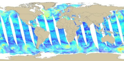
QuikSCAT Wind
QuikSCAT wind data
- Metadata: http://podaac.jpl.nasa.gov/PRODUCTS/p109.html
- Spatial Resolution: 0.25 degrees
- Extent: Global
- Temporal Resolution: twice daily
- Date Range: 1999-2009
- Format(s): HDF
- Access
Methods: FTP, OPeNDAP, POET, HEFT
- Data Access: http://podaac.jpl.nasa.gov
- CoML visualization guidance: TBD
Use Example
Download an daily HDF file and convert to an ESRI GRID with ArcGIS.
- Data Download: ftp://podaac.jpl.nasa.gov/pub/ocean_wind/quikscat/L3/data/2009/
ftp://podaac.jpl.nasa.gov/pub/ocean_wind/quikscat/L3/data/2009/QS_XWGRD3_2009028.20090291346.gz
file name convention QS_XWGRD3_YYYYDDD.YYYYDDDHHMM[GMT].gz- Data Conversion: These instructions assume local access to ESRI's ArcGIS software - access to ArcGIS via remote desktop is also available. These instruction require the Marine Geospatial Ecology Tools (MGET) for ArcGIS.
Export HDF header using Marine Geospatial Ecology Tools -> Data Management -> HDF Files -> Extract HDF header
Subdatasets within are:
ascending and descending (overpass) speed: asc_avg_wind_speed, des_avg_wind_speed
ascending and descending (overpass) U component: asc_avg_wind_vel_u, des_avg_wind_vel_u
ascending and descending (overpass) V component: asc_avg_wind_vel_v, des_avg_wind_vel_v
In ArcGIS Toolbox find Marine Geospatial Ecology Tools -> Conversion -> to ArcGIS raster -> from HDF SDS -> Convert SDS in HDF to ArcGIS Raster
Enter the HDF file name to convert and raster output file name
Use the following parameters:
SDS name: asc_avg_wind_speed
X coordinate of LL corner: -180
Y coordinate of LL corner: -90
Cell size: 0.25
pre-conversion processing: check "Swap Hemispheres" and "Flip"
post-conversion processing: input the follow scaling equation in the "Execute map algebra expression": inputRaster * .01
