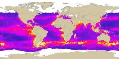
Ocean Primary Productivity
Primary productivity data
- Metadata:
Photosynthetic rates derived from satellite-based chlorophyll concentration (Behrenfeld and Falkowski.
1997)
- Spatial Resolution: 5' (~7.5 km) and 10' (~15 km)
- Extent: Global
- Temporal Resolution: 8-day, Monthly
- Date Range: 2002 - 2007
- Format(s): HDF, XYZ text file
- Access
Methods: HTTP
- Data Access: http://www.science.oregonstate.edu
- CoML visualization guidance: TBD
Use Example
Download an 8-day productivity dataset at 5' resolution as an HDF file and visualize in ArcGIS
- Data Download: http://orca.science.oregonstate.edu
- Data Conversion: These instructions assume local access to ESRI's ArcGIS software - access to ArcGIS via remote desktop is also available. These instruction require the Marine Geospatial Ecology Tools (MGET) for ArcGIS.
Extract header with MGET. From Marine Geospatial Ecology Tools -> Conversion Tools -> From HDF SDS -> Convert SDS in HDF to ArcGIS Raster
Enter the HDF file name to convert and raster output file name. Use the following parameters:
SDS name: ???
X coordinate of LL corner: -180
Y coordinate of LL corner: -90
Cell size: 0.0833
Define the new dataset's projection: Data Management Tools -> Projections and Transformations -> Define Projection
Select -> Geographic Coordinate Systems -> World -> WGS 1984
