AVHRR Sea Surface Temperature
AVHRR Oceans Pathfinder SST data
AVHRR Oceans Pathfinder SST
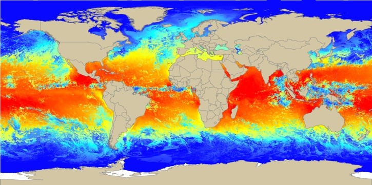
The 4 km Pathfinder effort at NODC and the University of
Miami's Rosenstiel School of Marine and Atmsopheric Science* (RSMAS) is
an extension of and improvement on the sea surface temperature (SST)
fields from the older NOAA/NASA AVHRR Oceans Pathfinder project. In
this 4 km Pathfinder project, some important shortcomings in the old 9
km data have been corrected, and the entire 1985-2001 time series
reprocessed at the 4 km Global Area Coverage (GAC) level, the highest
resolution possible globally.
- Metadata: 4 km Pathfinder Version 5.0 User Guide
- Spatial Resolution: 4km
- Extent: Global
- Temporal Resolution: Daily, 5 Day, 7 Day, 8 day, Monthly, Yearly
- Date Range: 1985-2007
- Format(s): HDF SDS version 4
- Access Methods: HTTP, FTP, LAS, OPeNDAP
- Data Access: http://www.nodc.noaa.gov/SatelliteData/pathfinder4km/available.html
- CoML visualization guidance: TBD
Use Example
Download a daily SST (daytime) HDF file for Jan 1, 2006 via HTTP and convert for use in ESRI ArcGIS.
- Data Download: http://data.nodc.noaa.gov/pathfinder/Version5.0/Daily/
file naming convention: OBSDATE.[BITCODE][RESO][AVGPERIOD][DAYNIGHT][VERSION]-TYPE(-BITS).hdf
- Data Conversion: These instructions assume local access to ESRI's ArcGIS software - access to ArcGIS via remote desktop is also available. These instruction require the Marine Geospatial Ecology Tools (MGET) for ArcGIS.
